Monday, July 20, 2009
Qld - Thursday Island
While staying at Seisea, the northern most town in Australia, about 40 km from the tip, we decided to take a day trip to Thursday Island.
Thursday Island is 30km off the Cape York Peninsula in the heart of the Torres Strait. The people are lovely and friendly and the island had a real Polynesian feel about it. I love the accents of the people and could listen to them talk all day. Years ago, the island had a huge pearl shell industry, mainly for making buttons, and unfortunately over 700 Japanese divers lost their lives due to the bends. They are buried in the local cemetery where there is now a memorial dedicated to their lives. Today, the main industries are cray fishing and tourism.
We hired a local taxi driver, Slim, who took us on an island tour and showed us all the interesting spots. The island is only about 3 kms around, so the tour was only about an hour long.
At the dock we watched the barges arriving. Everything on the island, including food, has to be brought in.
The island is very relaxing and you almost feel like you are in a time warp about 50 years ago. ((Nice feeling actually.)
Friday, July 17, 2009
Qld - Cape York
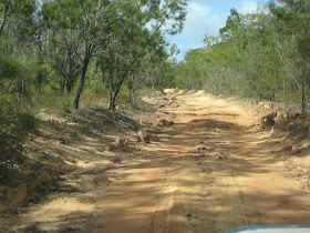
During the last two weeks we have driven over 1,300 klms from Cairns to the tip of Cape York and down to Cooktown over some good roads, some shocking roads, water crossings and everything else in between. We have dust in every part of our car, inside and out and thank goodness for plastic containers or we would have dust in our clothes and food as well. For two days Mike had a tinge of red in his hair from all the dust, (Quite a look!) My feet have been covered in dirt all the time except for the three nights that we camped where there was grass. Every other night we camped on either sand or dust. But, the experience was worth all the discomfort. We have stood on the northern most tip of Australia and it felt mighty good.
There were some roads that we didn’t tackle as people were getting winched out of the water, and smashing the sides of their vehicles when they hit submerged rocks while crossing some of the creeks. We have a long way to go around Australia yet, so babysat our car a little. In the six weeks that the road has been open this season, they have shipped 100 damaged 4 wheel drives back to Cairns and we didn’t want to be anotherstatistic.
The most frustrating thing for us was that the beaches are beautiful with fine white sand but, because of the crocodiles you can’t swim. We did find some fabulous waterfalls to swim at - The Saucepan, Eliot falls and Fruit Bat Falls. We swam and camped at these places both on the way up to the tip and back down.
Mike and I would consider going again but next time we would hire a vehicle that we wouldn’t have to worry about damaging that was more suitable for the rough going. It will have to be a while off as we are still remembering the kilometre after kilometre of corrigation where it was so bad that we could only go about 20 klms per hour. But, I figure it is just like childbirth really, after a while you forget all the bad stuff and decide to have another go.
Wednesday, July 1, 2009
Qld- Mission Beach
We have had a very entertaining few days since leaving Townsville. We have seen a loading ramp that stretches 6kms out to sea to load sugar onto the ships.
While at Tully we travelled to up the Tully river and were entertained by a group enjoying their white water rafting.
While staying at Mission Beach we decided to spend the day at Dunk Island. We travelled there and back by water taxi, lay by the pool, swam in the ocean and had a delicious meal at the Dunk Island jetty restaurant.
We spent two of the last four nights camping by the beach at great rest areas. One cost us $12.65 and the second was $16.00. What a bargain.
Tomorrow we head for the Cape so the next blog from us will be when we return, unless we find that we have computer connection up there.
Qld- Charters Towers
Charters Towers is a charming country town about 130 kms west of Townsville and we popped out there for the afternoon.The gold boom between 1872 and 1899 brought people, activity and prosperity to the area. The buildings in the main street have the original facades and you could easily imagine this place in the 1900’s with the horses and carts in the streets. I wanted to see this place because many of the “Australiana” books that I have been reading lately mention Charters Towers as being very important while the state was being populated.
On the way we crossed the Burdekin River which is very wide and at the moment is more sand than water. On the river bank there is a flood marker which in the floods of 1946 was up to 21.7 metres. I can’t imagine where the water comes from as
this area seems quite flat.